Basic Business Cards
If you would like to print some business cards for your chapter, and help promote this site as well – you can download and print these on lightweight card paper.
RHV Business Cards (Business card for this site, you can write your details on the back)
[Download These Business Cards]

.
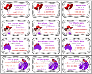
Chapter Business Cards
Add your details in the spaces before you print. Single page has 4 designs, 12 cards to a page (Simply cut alone the lines)
[Download These Business Cards]

Blank Cards
If you can’t add the details before printing, you can simply print this set of blank cards and write your details in the spaces after you print). Single page has 4 designs, 12 cards to a page (Simply cut alone the lines)
[Download These Business Cards]


 You can print off these tokens to use as markers for things like bingo cards or other games – or use them as table scatters or even cupcake toppers!